di Antonio Pietro LATINI (Jiangsu University)
 Antonio Pietro Latini, Architetto (Sapienza) ed urbanista (Columbia), per due volte Fulbright Fellow, è membro effettivo dell’Istituto Nazionale di Urbanistica dal 1997. Ha svolto attività disciplinare come dirigente di struttura pubblica e di società di proprietà pubblica. Ha tenuto corsi in materie urbanistiche in numerose università americane ed italiane tra cui Columbia, Puerto Rico, IUAV, Roma Tre, Trieste, Sapienza, Notre Dame ed è autore di testi di progettazione urbana, pianificazione e governo del territorio. Attualmente è Jinshan Distinguished Professor. Con questo articolo inizia la sua collaborazione con Abou Art.
The toponymy shown in the map of Rome by Giambattista Nolli (1748) indicates many streets, alleys, squares named after crafts or trades.
The map records also several churches and oratories that carry reference to a craft or to a trade in their name. This paper illustrates their location, general nature, and syntax of these urban components and show that this lay-out is less casual than one would expect. Simple conjectures about if and how these data may carry information on the actual distribution of crafts and trades in late-baroque Rome are proposed.
-
Nolli’s map
1.1. Rome in the mid-18th century
The city represented in the map published by Giambattista Nolli in 1748 is probably the most beautiful and architecturally significant city of its time. It is the fabulous destination of the Grand Tour, the product of marvelous transformations of the medieval fabric during the Renaissance and especially during more than hundred years of the diffused transformations of Baroque and late-Baroque architecture and urban design. It is also a city that is becoming a true “capital” with important functional additions of not only extraordinary urban spaces (such as piazze and strade, especially from the papacy of Alexander VII Chigi (1655-67) on) but also high-ranking services and administrative buildings (harbors, granaries, educational, prisons, hospitals, theatres, custom houses, cemeteries).
Though at a slower pace than in other European cities undergoing the transformations deriving from major demographic and industrial changes, production and commerce activities kept concentrating in Rome’s urban fabric. Despite the presence of an ambitious infrastructural system made of roads and hydraulic network, starting with the late 16th century, after the papacy of Sixtus V Peretti (1585-90), Rome was being regenerated and densified rather than expanded. Between the late 16th century and the second half of the 19th century, when Rome became the administrative capital of the new Italian Kingdom, the overall layout of the city remained substantially the same.
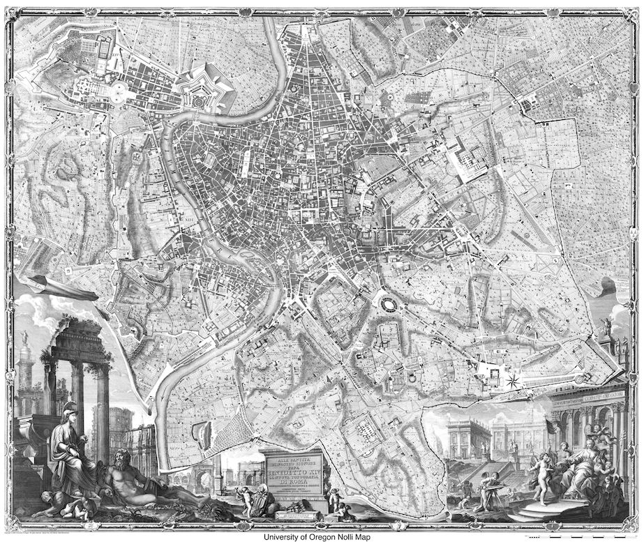
Rome as it is represented in the Nolli map is still a city, a large one, made of traditional, mostly medieval fabric and patterns. Its mix of building types and intertwined coexistence of residential, administrative, service and production uses have made it a paradigm for present day urban designers. The map by Nolli is the first “scientific” map of Rome and its first ichnography, after many three-dimensional representations, since the publication of the coarse map by Bufalini of 1551. When compared with present maps and aero-photographs it proves to be surprisingly accurate in consideration of the date of its production.
Because of its figure-ground format as well as its being a cherished image of a pre-industrial city, the map of Rome by Nolli has been extraordinarily familiar, popular and fashionable among architects, at least for half a century. In 1978, it was the basis for the exhibition “Roma interrotta”:[1] a milestone in the recent history of architecture and urban design. The University of Oregon has produced a well-known website dedicated to it: possibly the most important on the subject worldwide.[2]
The map was the product of many years of surveys. It is a “package” made of three maps: a large one made of twelve plates, a small one in one plate and a reproduction and graphic update of the precedent map, made by Bufalini about two centuries before. The study in this paper is based on the findings in the large map which is the most detailed and copious of data.[3]
1.2. Information in the map
Besides being a beautiful graphic product and the representation of the ideal public-space-centered, multi-functional fabric, a model for present architectural theory, the map carries many data on the mid-18th century city, including the name and location of 1320 urban elements. These elements are listed in two indexes. One is organized by their location in “rioni”. A rione is an administrative unit of the city of Rome, within the walls. Since 1586, the city was divided in 14 rioni. They had been reorganized and better defined in their boundaries shortly before the publication of the Nolli map.
The second index is organized by building type. Types (among others) that are of interest here are: churches (chiese de secolari o con monasteri conventi ospizi & c), oratories (oratory), squares (piazze), streets (strade) and alleys (vicoli). Related numbers refer to a position in the map. The data base used in this text is taken from this second index, integrated with the first index as needed, as in some case names in the two lists are different.

-
Crafts and trades in the map by Nolli
2.1. Reference to crafts and trades in the name of urban spaces
In the index referred to above one can find a number of public spaces named after a craft of a trade. I list them below. Usually, these names refer to activities that imply the presence of a shop for both production and sale. Urban spaces dedicated to an outdoor trade are included as well. This is certainly the case of the two squares and two streets named after the carrette: the carts on which fresh produce was temporarily laid out for sale in the open space but it is reasonable that it applies to other instances, too, as discussed below. Names of other public spaces refer to a specific production located close by, as in the case of fornaci (klins for the cooking of clay), of mole and similar (water mills). In one case, a direct reference to a fabbrica, the factory of tobacco, is listed.
There are 19 streets, 13 alleys, and 12 squares which names recall a working activity. I list them below with their most likely English translation.
Strade Streets
Strada de’ Baullari Trunk -makers
Strada de’ Canestrari Basket-weavers
Strada delle Carrette (2) Carts (produce market)
Strada delle Carrozze (2) Coach renters
Strada de’ Chiavari Key-makers
Strada de’ Coronari Crown/rosary-makers
Strada de’ Falegnami Carpenters
Strada de’ Giupponari Coat-makers (taylors)
Strada del Macello Slaughterhouse (Butcher)
Strada delle due Mole (Two) Mills
Strada di Pescaria Fish Market
Strada de’ Pettinari Comb-makers
Strada de’ Salumi Cold cuts
Strada de’ Sediari Chair makers
Strada de’ Sediari e Taccari Chair and wedge-makers
Strada de’ Sugarari Cork workers
Strada de’ Vascellari Potters
Vicoli Alleys
Vicolo de’ Balestrari Crossbow-makers
Vicolo del Canestraro Basket-weaver
Vicolo de’ Capellari Hat-makers
Vicolo de’ Carbonari Charcoal-sellers
Vicolo de’ Cartari Papermakers
Vicolo de’ Cestari Basket-weavers
Vicolo de’ Cimatori Fabric-croppers
Vicolo de’ Leutari Lute-makers
Vicolo delle Mole Mills
Vicolo della Moletta Mill
Vicolo de’ Saponari Soap-makers
Vicolo de’ Sediari Chair-makers
Vicolo de’ Vascellari Potters
Piazze Squares
Piazza de’ Caprettari Goat-sellers
Piazza delle Carrette (2) Carts (produce market)
Piazza de’ Cimatori Fabric croppers
Piazza delle Fornaci Furnaces
Piazza di Macel di Corvi Slaughterhouse (Butcher)
Piazza due Macelli Two slaughterhouses (Butcher)
Piazza de’ Macelli Slaughterhouses (Butcher)
Piazza di Molara Mill
Piazza di Pescaria Fish Market
Piazza Pollaroli Poultry-sellers
Piazza de’ Vascellari Potters
Some references recur more than once. Three squares and one street have names referring to butchers or slaughterhouses and three more squares are named after similar trades: poultry dealers, goat-butchers, and fishmongers, and one street after “cold-cuts” (salumi), likely pork-butchers. Two streets and one alley are named after chair-makers and one street named after carpenters. Basket weavers (canestrari and cestari) and potters (vascellari) are referred to in one street and one alley each. A square too is named after the latter. Two street names refer to carrozze (coaches). At least in one case, in the Northern rione Campomarzio, we know that the street was a good place to rent a coach—rather than a street with a large coach traffic. The same interpretation is applied to the second street with the same name, in the Southern rione Campitelli, by analogy. Four open spaces are referring to a water mill close by.
2.2. Reference to craft and trade in the names of churches and oratories
According to the index, 33 churches and 9 oratories carry a reference to a trade or craft in their names. Their list follows. It must be highlighted here that not all religious buildings dedicated to a specific work activity are listed. Many more are in this condition but do not include their dedication in their names. Further, this list represents the situation in 1748. Some church or oratory dedication have changed during the years.
Chiese Churches
Cosma e Damiano de’ Barbieri Barbers
Sant’Anna de’ Calzettari Sox-makers
Bonosa de’ Calzolai Shoemakers
Sant’Aniano de’ Lavoranti Calzolaj Shoemakers
Carlo a Catinari de Barnabiti Washbowl-makers
M. in Cacaberis de’ Cocchieri Coachmen
Sant’Elena dei Credenzieri Home workers
Vincenzo e Anastasio de’ Cuochi Cooks
Giuseppe de’ Falegnami Carpenters
Sant’Eligio de’ Ferrari Blacksmiths
Maria delle Fornaci de’ Trinitari Brick makers
M. di Loreto de’ Fornari Italiani Bakers
Santa Elisabetta (Un. Garzoni Ted. Fornari) Baker’s boys
Santa Barbara de’ Librari Booksellers
M. della Quercia (Univ. d. Macellari) Butchers
Biagio e Cecilia de’ Materassari Mattress-makers
Sebastiano de’ Mercanti Merchants
Gregorio de’ Muratori Masons
Benedetto e Scolastica de’ Norcini Pork-butchers
Sant’Eligio degli Orefici Goldsmiths
M. dell’Orto Orchard
Biagio degli Osti Hosts
Sant’Anna de’ Parafrenieri Grooms
Sant’Angelo in Pescaria Fish Market
Martina e Luca de’ Pittori Painters
Sant’Andrea e Bernardino dei Rigattieri Junk dealers
M. in Vinci de’ Saponari Soap-makers
Omobono de’ Sartori Taylors
Silvestro degli Scultori e Scarpellini Sculptors
Sant’Eligio dei Sellari Saddlers
Lorenzo in Miranda degli Speziali Pharmacists
Sant’Agata dei Tessitori Fabric weavers
Bartolomeo de’ Vaccinari Butchers
Oratorj Oratories
S. M. del Riscatto d. Acquavitari e Tabaccari Spirit- and Tobacco-sellers
San Cosma e Damiano de’ Barbieri Barbers
San Giacomo Apostolo de’ Cappellari Hat-makers
San Giuseppe de’ Falegnami Carpenters
Sant’Eligio de’ Ferrari Blacksmiths
San Gregorio de’ Muratori Masons
Sant’Andrea de’ Pescivendoli Fishmongers
Sant’Andrea Vinci d. Scultori e Scarpellini Stone cutters
Sant’Andrea di Vascellari Potters
Some references to work activities are recurring more than once among churches and oratories names. Sometimes, references in the list of religious buildings are the same that occur in the names of open spaces. For instance, activities referring to some form of meat or fish dealership, that are abundant among open space names, are found in the names of three churches and one oratory. Carpenters (falegnami) appear in the name of one church and one oratory, shoemakers (calzolai) and bakers (fornai) appear in the names of two churches, barbers (barbieri) in the names of two churches and one oratory. Blacksmith (ferrari) have one church and one oratory to which one could add a church—designed by Raphael—dedicated to the goldsmiths (orefici).
2.3. Distribution of public spaces and of religious buildings by rione
The distribution of urban element that carry the name of a craft or a trade in their name by rione is an initial indication of the geographic distribution of the phenomenon. If open spaces only are considered, they are distributed with high recurrence in Trastevere (8), which is a large, popular rione, in the rioni in the lower bend of the river (Parione: 6, Regola: 5, S. Eustachio: 4, S. Angelo: 4) and in Monti, another large rione (4).

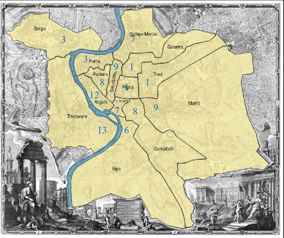
An analogous distribution is confirmed if religious buildings with names of crafts and trades are added to the count. Most recurrences appear in Trastevere (13) and Regola (12). Campitelli and Ripa rank higher than in the previous list. At first glance, in both distributions the rioni in the north-west (Borgo and Ponte) and centre-north-east (Trevi, Colonna and Pigna) rank low, with a concentration of urban elements considered in the rioni on both sides of the central section of the river.
-
Mapping the urban elements.
As anticipated, all urban elements listed in the indexes attached to the map are positioned in the map by a reference number. Since churches and oratories are represented in the map with their plan, it is easy to detect their precise position. Also, the exact perimeter and configuration of public spaces is easy to determine in most cases. In some instances, the actual perimeter of streets or alleys is not certain but simple reasoning reduces doubts to an inessential minimum.
The following overall map reports the strade in red, the vicoli in orange, and the piazze in yellow, carrying the name of a craft or a trade with their likely configuration. It must be underlined that not all public spaces have names and especially side streets may have been referred to as extensions of the main public space. These cases, however, have not been considered while drawing the map.
Chiese and oratory are represented with dots, respectively violet and light blue. The Fabbrica del tabacco is represented as well, in brown. For reasons that will be clarified below, two major tourist and religious itineraries are indicated too: the Via Peregrinorum and the Via Papalis.

3.1. Semantics
The reading of the map offers a few pieces of information on the nature of the elements described and on their distribution and syntax.
Many streets and a few alleys that carry the name of crafts or trades seem to be particularly long compared to others. See for instance: Strada de’ Coronari, Strada delle Carrozze in Campitelli, Strada de’ Chiavari, Strada de’ Falegnami, Strada del Macello, Strada Pescaria, Strada de’ Pettinari, Strada de’ Sediari, Strada de’ Vascellari. This circumstance may be determined by a generally longer dimension of streets with a name or from the additional fact the in most cases streets that are named after a craft or a trade are major connecting streets. The latter hypothesis seems plausible, in many cases, as mentioned below.
Squares that carry the name of crafts or trades are often smaller than the most well-known baroque piazze in Rome. In a few cases (Piazza de’ Cimatori, Piazza due Macelli, Piazza Macel de’ Corvi, Piazza Macelli) the fact that the space has the attribution of being a piazza seems to be depending on the specific activity—in three cases out of four a meat market—possibly located there periodically rather than permanently, rather than on their actual configuration as a proper piazza. Piazza Pollarola (poultry), Piazza Pescaria (fish) and Piazza de’ Caprettari (goat) are dedicated to the trade of edible animals, too. Two piazze are devoted to the produce market (Piazza delle Carrette). The only very large square with a name deriving from a work activity is Piazza delle Fornaci which derives its name from the presence of furnaces in the surroundings.
Churches and oratories that carry the name of crafts or trades are usually small and not particularly memorable buildings with only few exceptions, as San Carlo ai Catinari which is a large church. However, the name Catinari (washbowl-makers) seems to refer to the area in which it is located rather than to a specific affiliation. S. Maria di Loreto (bakers) is a medium size church by Antonio da Sangallo the younger. Sant’Eligio degli Orefici (goldsmith) is a small church designed but not completed by Raphael.
3.2. Syntactics
When locations of open spaces named after crafts and trades are considered, and their syntax, a meaningful lay out surfaces. Not only most of them are concentrated in a few rioni, as anticipated above, but they often form clusters and sometimes are contiguous and in continuity.

In one case street, alley, square and oratory sharing the same reference are grouped together. This is the case of the potters (vascellari) in the South of Trastevere. The major cluster, however, is in the lower bend of the Tevere, affecting several rioni. It includes a substantially continuous set of elements such as Vicolo de’ Cappellari, Piazza de’ Cimatori, Strada de’ Baullari, Piazza Pollarola, Vicolo de’ Balestrari, Strada de’ Giupponari, Strada de’ Falegnami, Strada di Pescheria, Piazza di Pescaria, Strada de’ Sugarai, Strada delle Carrozze, Vicolo dei Saponari, in the direction roughly going from North-West to South-East, and Strada de’ Pettinari, Strada de’ Chiavari, Strada de’ Sediari e Taccari, Strada de’ Canestrari, in the opposite direction, crossing on Strada de’ Giupponari. A minor system is in Campomarzio and includes Strada del Macello, Piazza delle Carrette, Strada de’ Sediari, and Strada delle Carrozze. The latter however does not seem a structural system but rather accidental.
The distribution of churches and oratories does not appear to follow any specific pattern. Religious buildings carrying names of crafts or trades are sometimes found along streets taken into consideration here, but this condition is not recurrent in a way that encourages conjectures of some form of rationale. Only in few cases a religious building is located adjacent to a public space with similar reference. This is the case of the Vascellari (potters) and the Pescheria (fish market) clusters, mentioned above, and of alley and oratory of the Saponari (soap-makers). Sometimes a church and an oratory dedicated to the same activity are coupled: Barbieri (barbers), Falegnami (carpenters), Ferrari (blacksmiths), Muratori (masons). These cases are the only ones in which recurring names or names of similar trades belong to urban elements that are in fact contiguous.
Finally, it is worthwhile examining the correlation between the configuration of urban elements named after crafts and trades as it emerges from the map and the general lay out of the city. It is of some interest comparing the distribution of public spaces considered here and the two most important religious and tourist itineraries of the city: the Via Peregrinorum, “street of the pilgrims”, the itinerary leading from the Vatican to S. Paul outside the walls, the second major church in Rome; and the Via Papalis, “street of the Pope”, the path connecting the Vatican and the Lateran and S. John, the cathedral of Rome.
It is strikingly evident that the central cluster described above is related to these two important itineraries. Four public places are themselves parts of the Via Peregrinorum, also named “street of the markets”, in fact. Besides these four, there are nine more public spaces directly connected to this major street. Also, four streets intersect the Via Papalis and two of them connect Via Peregrinorum and Via Papalis. It is plausible that they were areas of concentration of specific activities, non-daily products, looking for a visibility condition along the most used urban corridors.
On the contrary, many squares related to markets of daily products—many to meats or fish markets as well as produce market (carrette)—are in peripheral areas. This is true also for the two streets with the same name. It is possible that they were the daily locations of trades for goods coming from outside the city and therefore avoiding to proceeding closer to the center city. Urban elements related to factory-like, pre-industrial production (fornaci, tobacco), are in the North-West and South-West periphery of the city, possibly for their need to be close to the quarries or simply for their need of larger spaces. Finally, a few names refer to the mole (water mills) and their associated urban elements: almost all of them are located close to the Tevere, in the Trastevere and Isola Tiberina area.
- Conclusions
The Nolli map of Rome represents the “eternal city” as it was in the middle of the XVIII century. Its fabric was accommodating all sorts of uses: residential, administrative, services and production in a mix that seems to us a good model for our future settlements. The toponymy illustrated by the map shows 44 urban public spaces named after a craft or a trade (or both) and their nature suggests that these were, in fact, places of concentration of the activities referred to in the names. This seldom seems to apply to the 42 religious buildings (churches and oratories) with a name referring to a work activity. The spatial distribution of these urban elements suggests a few underlying rationales the most impressive of which is the concentration of many urban spaces carrying the name of the production and commerce of non-daily goods in one section of the center of the city, in direct connection to the most important urban itineraries: the Via Peregrinorum and the Via Papalis.
Table 1. Crafts-and-trades-in-Nollis-Rome.pdf
Antonio Pietro LATINI, Zhenjiang, 22 agosto 2021
ITALIAN ABSTRACT
La mappa di Roma di Giambattista Nolli (1748) è forse la rappresentazione di città più nota non solo tra storici dell’arte e dell’architettura ma anche tra architetti e urbanisti professionisti. Mostra quello che fu per un lungo periodo il supremo modello per l’architettura e l’urbanistica e l’esclusiva destinazione del Grand Tour. La mappa stessa è tanto un mirabile esempio di arte grafica quanto il risultato di una tecnica di rilievo estremamente avanzata.
Durante la seconda metà del XX secolo e fino ad oggi, la mappa del Nolli è stata un riferimento per la teoria e la prassi in architettura e in urbanistica, in particolare dopo il suo uso nella fondamentale mostra “Roma interrotta”, del 1978. La rappresentazione duale in bianco e nero (di fatto “rigatino”) è stata, da allora, lo strumento quintessenziale per le rappresentazioni in figura/sfondo di vuoti e pieni urbani e un prototipo in innumerevoli studi e progetti, in tutto il mondo.
La mappa è anche uno strumento estremamente sofisticato, che riporta una quantità di informazioni sulla città di Roma durante uno dei più alti momenti della sua esistenza. Grazie al suo eccezionale dettaglio, è indicata una grande quantità di componenti urbane, con i rispettivi nomi, riportati per categoria in elenchi separati. Tra questi i nomi di strade, vicoli e piazze e di edifici più importanti tra cui chiese ed oratori.
In questo testo sono considerati tutti gli elementi urbani ed architettonici intitolati a mestieri o a commerci, ed interpretati la loro localizzazione, il tipo, e la sintassi, supponendo che l’immagine che ne scaturisce possa riportare informazioni sulla effettiva distribuzione di mestieri e attività commerciali nella Roma della metà del XVIII secolo e contribuire così a capirne il sistema urbanistico. Mentre la distribuzione topografica di edifici religiosi intitolati a mestieri o commerci non mostra alcuna trama evidente, la toponimia degli spazi pubblici indica un significativo addensamento lungo i due corridoi della Via Peregrinorum a della Via Papalis, molto probabilmente i percorsi più frequentati in quel periodo.
NOTE